|
On this page you can view our actual and planned routes. At the end a chart lists actual miles along with a mileage guesstimate for the remaining miles. For a full detailed day-to-day listing see our Stops page.
We changed this last on 2 September 09.
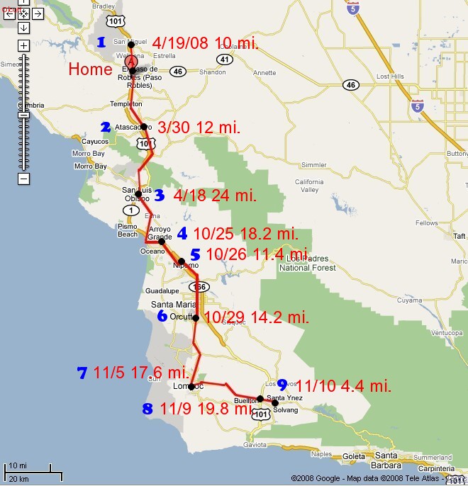
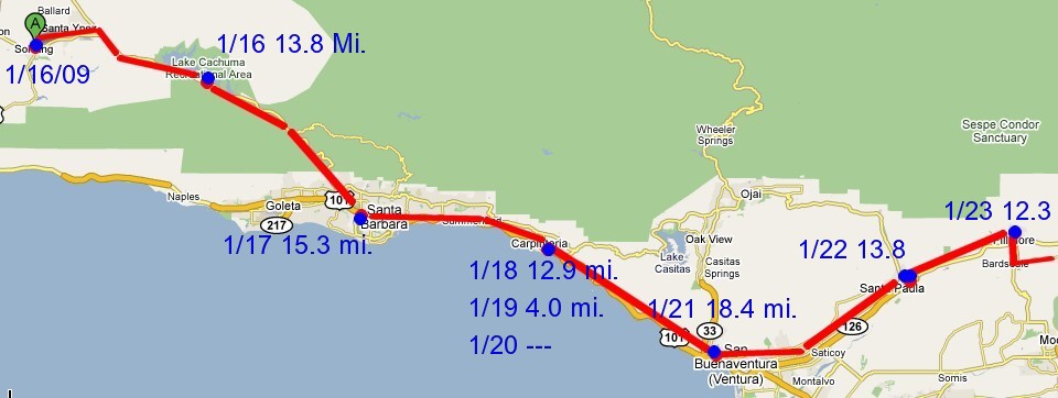
We walked this first 134 miles in 2008 to get a feel for walking on U.S paths as opposed to European ones we are accustomed to walking. We'll start in Solvang when we start the walk 16 Jan.
The detailed maps have proved to be hard to implement on the fly.
The following composite will have to do until I do more later.
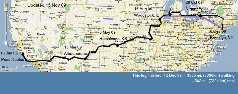
The black line shows how we have walked so far. After Woodstock, the black line overlays the colored line, the proposed route as of Woodstock. Updated as indicated in the upper right.
Plan for Western Europe
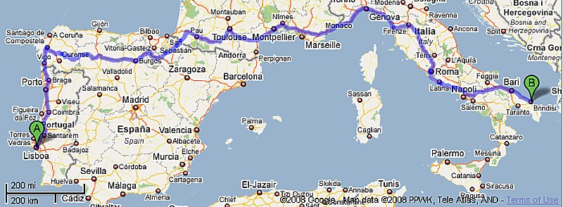
The planned route in Europe begins with a boat to Lisbon, we will return to Santiago and Finisterra for a reunion of sorts. Then we'll walk the Camino de Santiago against the 2010 Holy Year flow and move on across southern Europe to Rome, unless we decide to walk the Dalmation Coast instead.
Actual Western Europe
So much for the planned route. Here are the actual routes as we complete them. The beginning is actually quite close to the plan.
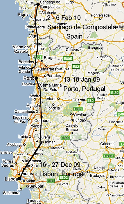
After flying to Lisbon we followed this route to Santiago de Compostela resting in Lisbon, O Porto, and Santiago. We will walk to Finisterra on the Atlantic next week before taking off the rest of February to celebrate Petra's Mother's birthday in Germany.
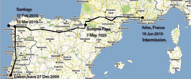
I then returned from Petra's Mother's birthday in Germany March and continued east. Petra rejoined me in Santo Domingo, Spain and walked on together to Arles. We stopped there and are digesting now.
Plan for Eastern Europe
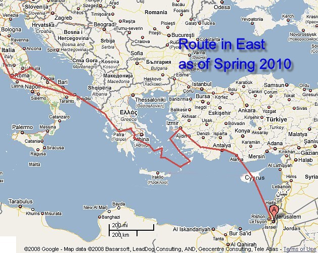
Where precisely we go after northern Italy stood much in the air for some time. We had several possibilities. The banner map on the journal and the map on the planning page reflects these possibilities. As we walked across France we honed it out to something like this. It too can still change as we move forward.
To see details of the route go to the Route planner page. I will be using that page as we walk to hone the actual path we walk.
How many miles
How can we begin to guesstimate the miles we will walk? We lay out a plausible route and measure it. We will surely walk a different route in the end but the distances will have some accuracy (80-90%?) because we will follow the same general route. Only when we really wander around here and there along the way will they be farther off. With that in mind, the following table is our guess today.
The places we have already visited are in bold (save for the final total)--I'll update more as I get time. See the Statistics page for the latest totals.Other numbers are only estimates.
| California to Jerusalem (bold = completed) | Miles | Kilometers |
|---|
| From | To | Leg | Accum | Leg | Accum |
|---|
| Paso Robles | Albuquerque | 1218 | 1218 | 1973 | 1973 |
|---|
| Albuquerque | Santa Fe | 83 | 1301 | 134 | 2108 |
|---|
| Santa Fe | Hutchinson, KS | 671 | 1972 | 1087 | 3195 |
|---|
| Hutchinson, KS | Woodstock, IL | 1222 | 3194 | 1980 | 5174 |
|---|
| Woodstock, IL | New York/Lisbon | 1316 | 4510 | 2132 | 7306 |
|---|
| 4,752 miles flying the Atlantic - NYC-Brussels-Lisbon -with some car and walking. |
|---|
| Lisbon, Portugal | Santiago | 335 | 4379 | 543 | 7094 |
| Santiago | Marseille | 925 | 5304 | 1499 | 8592 |
| Marseille | Acquapendente | 490 | 5794 | 794 | 9386 |
| Acquapendente | Rome | 96 | 5890 | 155 | 9542 |
| Rome | Bari | 282 | 6172 | 455 | 9999 |
| Igoumenitsa, Greece | Sparta, Greece | 372 | | 600 | |
| This possible route crosses Crete, the Islands, southern Turkey, Syria, and Jordan |
|---|
| Creete guess | 310 | | 500 | |
| Islands guess | 186 | | 300 | |
| Mugla, Turkey | Adana Turkey | 381 | | 615 | |
| Adana Damascus | Jerusalem | 775 | 8663 | 1250 | 14033 |
|---|
Taking the earlier gross numbers we can come up with the following equally gross guesstimates based on to-New York numbers.
| Total walking miles/kilometers: | 8,663 mi. 14,033 km. |
|---|
| Weeks @ 100mi./wk: | 86.63 |
|---|
| Days: | 607 |
|---|
Copyright © 2008 Mike Metras, www.PilgrimageCreations.com
|