Review
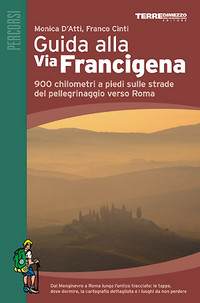
Guida alla Via Francigena
 Guida alla Via Francigena
by Monica D'Atri and Franco Cinti was published in 2006 by Terre di Mezzo in Milan, Italy. It is in Italian. It the guide we used as we walked the Via Francigena in 2006-07. We also used the Maps of Association Internationale Via Francigena (AIVF).
The Guida alla Via Francigena (Guida) has divided the VF into 38 sections. It describes two starting points. One at Montgenevre on the French border and the other at the Grand Saint Bernard pass on the Swiss border. The two routes join at Vercelli east of Pavia and then continue on to Rome.
Each section includes a table with the distance left to Rome, the length of the walk that day, and about how long it should take you. The book includes maps and detailed descriptions of the walk in addition to short description of some of the historical and religious sights you will be passing. It also includes suggestions for places to stay including religious institutions.
We used the Guida from where we joined the VF in Fidenza with around 557 km (345 mi.) to go to Rome. The Guida proves to be by far our most useful guide for the VF path itself. When the signs along the road don't help, most of the time the Guida's directions give us a good idea where to go. Sometimes the Guida is a bit sketchy at the beginning or end of a segment. And it seldom tells us how to get through cities well, at least until Lucca. Some of its maps aren't drawn proportionally so it's often hard to decide relative distances along the way solely by looking at the map. At those times we have to read the text in addition to consulting the maps, a tedious task for me when I'm on the move, especially since my Italian isn't terribly fluent. That all said, the Guida is a very useful guide.
I just noticed that Monica D'Atri and Franco Cinti have a new book of maps and GPS coordinates.
La Via Francigena: Cartographia e Gps published in May 2007. It has much better maps than the Guida and seems to be meant as a companion to the Guida. In their words:
La prima cartografia completa e dettagliata alla Via Francigena.
Oltre 800 chilometri a piedi, in 38 tappe, ripercorrendo l'antico cammino dal Monginevro a Roma. Tappa per tappa attraverso Piemonte, Lombardia, Emilia, Toscana e Lazio: le cartine e tutti i dati necessari per orientarsi.
3 grandi mappe interamente a colori, con tutte le tappe, ritagliabili singolarmente
- 40 cartine dettagliate
- in scala 1:30.000
- profilo altimetrico
- dati Gps completi
The book is in Italian. But check out the link and look at the sample pages. They look good. I could manage that Italian quite well.
Back to top.
Copyright © 2008-2012 Mike Metras, www.PilgrimageCreations.com
|