|
This is a work page. It is here so we can easily and quickly access maps to tell us where to go as we walk toward Jerusalem from California. It is a work in progress. We invite you to look along with us to see more or less where we are going and where we have been. I hope to keep it updated as we move along. But that is not important. This is for where we will be going. Updated 2 September.
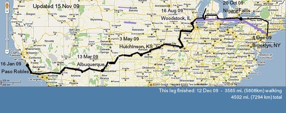
This the same map as is on the Graphics page. It is a general indication of where we have gone/will be going as we cross the US. It is not the exact route, just a general view.
The following maps will show detailed sections. These are here for you to view. But they really are our working maps. We will bring them up as we walk to determine precisely where to go from day to day. Click on back to return to this page. Use the Google scale on the side to change the view as you wish.
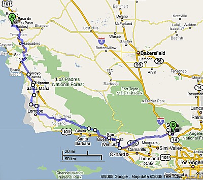
Paso to Santa Clarita shows you the approximate route of our first 205 or so miles. It is not totally accurate in the mountains north of Santa Barbara to Ventura where we are going to walk on forest service trails (never did) that are not in Google at this time.
| 
|
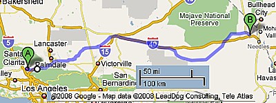
This is the next 175 or so miles from Santa Clerita to Klinefelter just before I40 near Needles. I created it with the walking version of Google and it would not let me mark I40 so I stopped at Klinefelter.
| 
|
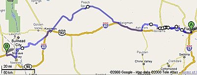
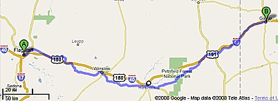
This section from Kleinfeller to Flagstaff, AZ should be useful though there are things to work out between Ash Fork and Flagstaff. This section is about 245 miles according to my detailed calculations. We have been following the route of old US route 66 since before Barstow, CA, and will continue to do so until Santa Fe, NM.
Back to top.
| 
|
This 217-mile is purely in the planning stage as I frist write this I'll use it as we walk from Flagstaff to Gallop, NM. But what I see here looks good. Brother Marty helped with his RV giving us rides and a place to stay at night across this section.
| 
|
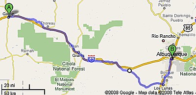
The 165 miles from Gallop to Albuquerque should take us to Albuquerque in time for the March 13-15 Gathering of the American Pilgrims on the Camino and by then we will have completed around 1,100 miles of our walk to Jerusalem.
| 
|
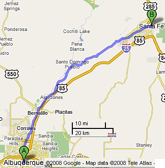
Next we head for Santa Fe where we will quit Hwy 66 and link into the Santa Fe Trail.
Back to top.
| 
|
|
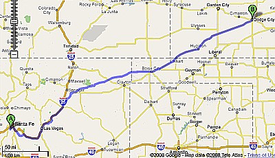
This will do fine for the beginning of the Santa Fe trail from Santa Fe to Marshall Dillon's Dodge City, KS (426 mines). This section was quite different. We walked over the mountains to Taos, New Mexico and then across to Cimmeron. NM where we joined the Santa Fe Trail. This plan was for the dry route of the trail. We followed the "wet" route along the Arkansas River.
| 
|
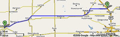
From here we are walking 154 miles to my sister Marcia's in Hesston, KS. Along the way we will stop in Hutchinson, KS, to see another sister, Edie.
Back to top.Here we also deviated, wandering back and forth to have short enough distances between towns.
| 
|
|
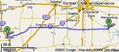
From here we will walk 213 miles to the beginning of the Katy trail in Clinton, MO. We never made it to Clinton but rather walked farther north to Independence. We joined the Katy before Boonville at Pilot Grove.
| 
|
|
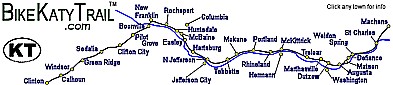
Now we walk the 225 miles of the Katy trail across Missouri. It follows the old Missouri-Kansas-Texas rail line (M-K-T, or "Katy" for short). The site has just about any map we may need of the Katy trail. There is also a link to the mileage table on the map page. There's even an elevations chart and GPS coordinates page for the route. Missouri gave us our hottest weather with some days over 111 degree degree days.
| 
|
Back to top.
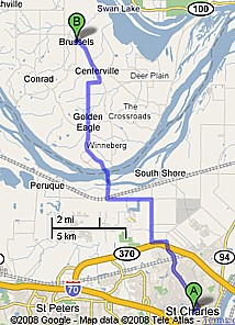
From the end of Katy at St. Charles we'll take a ferry to Brussels, IL, a short 16 miles. We went to Elsa, Illinois instead,
| 
|
|
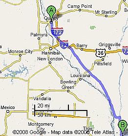
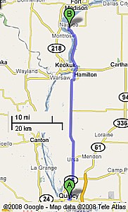
From Brussels, we head 88 miles up the Mississippi to Quincy, IL.
| 
|
The next stop (45 miles) is Navoo, IL.
Back to top.
| 
|
|
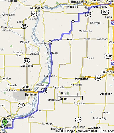
Now we move to the beginning of the Hennipen Canal in Green Rock, IL, just east of Rock Island.
| 
|
Camping along Hennipen Canal and other things from the Illinois Dept. of Natural Resources. canal Maps, pictures, elevations, and other things--nice page.
Back to top.
|
|
|
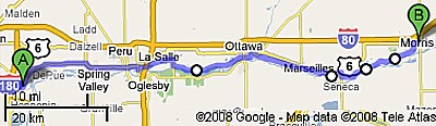
Have to walk from Bureau Junction to La Salle 18 miles. Here is whole 53 miles from Bureau Junction to Morris on roads because Google does not do canals. It is close to the canal but not all there.Camping along the I&M canal. I&M maps.We walked only to Ottawa and then followed the Fox River first to Montgomery along roads and then the rest of the way to Woodstock along the Fox River Trail.
| 
|
The following eastern-America routes are all here only for historical purposes because we have decided to walk to Milwaukee, take a boat to Muskegon, Michigan. From there we head directly east across Michigan, southern Ontario, and New York City where we will fly to Lisbon. As we leave Woodstock 2 September, we plan on getting to NY in early to mid-November. The European routes are still as we envision them.
Depending on where the ship leaves from the east coast, here are our options. See the map on top for these general routes.
At this time (Nov 08) we have little concrete feel where we will ultimately be going in Europe in late 2009 and 2010. So I'll just repeat the ending paragraphs from the main page here for now.
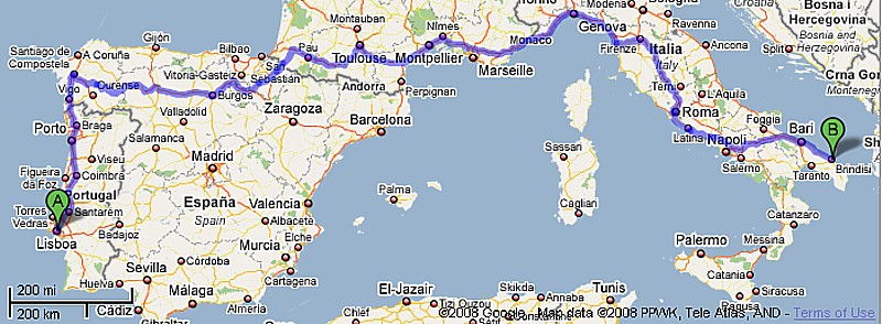
From Portugal or Spain, we'll will walk across southern Europe and then either down Italy to Rome and on to Bari and across to Greece. Our alternative to Italy is down the Dalmatian Coast of the Adriatic through Croatia and Albania to Greece. There is plenty of time to decide on one or the other. From this vantage point it looks like we'll walk the former, maybe even through Assisi rather than along the Via Francigena. And there is no reason to go to Rome since we have already been there and done that.
From western Greece we have many options:
- Greece, the Islands, Crete, and Cyprus
- The same but southern Turkey instead of Cyprus
- Greece as far south as Athens and across to Izmir, Turkey
- Greece as far south as Athens and back up to Istanbul, Turkey then either through Adana or along the coast and through Syria or through Cyprus
- And a hundred or so other combinations.
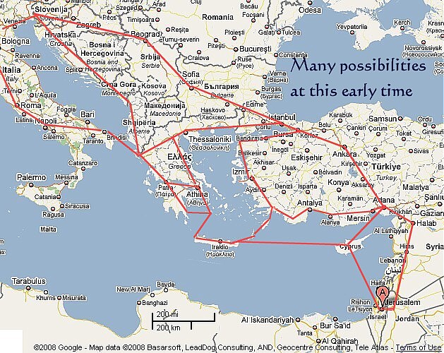
The rest of Europe and points east. All the above possibilities are here.
Back to top.
Copyright © 2008-2012 Mike Metras, www.PilgrimageCreations.com
|