 |
Across the street from the Hotel Ghinda a hundred-yard square, dusty field stood in front of the plain, concrete police headquarters. On April 14, 1970, in a coordinated attack against this police station and a pizzeria in Asmara, one of the Eritrean liberation movements killed six to eight police here and a judge and magistrate in Asmara. They were protesting the hanging of three members of their group in Asmara that day. The judge and the magistrate had taken part in the condemnation. I do not know the link to the police.
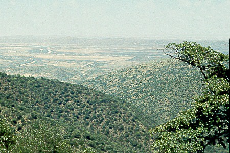
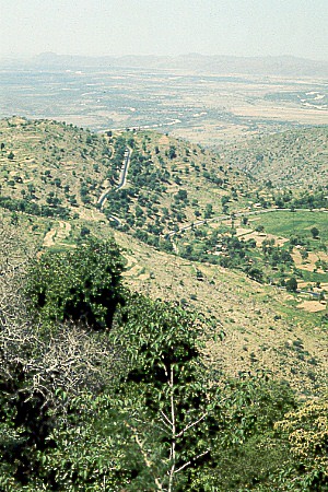
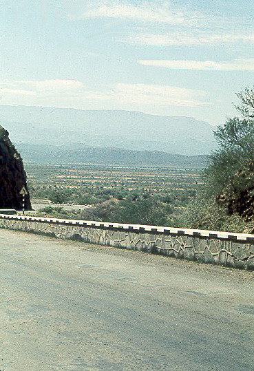
We were slow at getting up from the hotel's veranda. A fresh, cool breeze kept us lingering. But get up we did. We turned left out of the hotel compound and headed up through a wooded area. After a few uneventful kilometers, we arrived at the ridge that forms one of the edges of Ghinda's valley. The road turned right and followed the ridge. Though the road went up now and then, we slowly descended through thorn bushes and dead-tan, dry earth. We could taste the now dusty, dry, hot air.
|
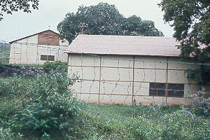
At one point in scrubby trees and heavy grass on the right, several old, pre-fab, cement buildings screamed, "We are military barracks." And that they were. I once thought this compound was part of the original Italian communications station, Radio Marina, the place taken over by the Americans and eventually renamed Kagnew Station. I had thought that the Americans moved it up to Tract A in Asmara as communications needs became more important and centralized. But Italy's Radio Marina was always in Asmara at Tract A. In fact, according to The Official History of Kagnew Station, published by the Army in 1973, these buildings were "commodious living quarters...built to house the labor force eventually intended for the Massawa Navy Base." The publication continues, "The Ghinda housing project for Massawa commuters was never used except as a Kagnew R&R center for a short time in the fifties." The buildings had been in disuse for some time by the late '60s when I passed that way. They didn't look inviting.
 |
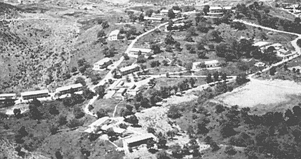 |
(picture from Official History of Kagnew Station) |
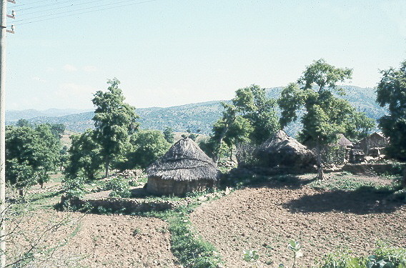
Now the road quickly dropped through several switchbacks and considerably steeper grades. At one place on a little hill several round, thatched, stick buildings stood in a group to the right. Though not unusual, these tukuls were the first ones seen by Americans running from American compound to American compound. Tukuls are the traditional Ethiopian house, found in most rural villages. These mud and wattle buildings had roofs of sticks and grass. Until this point, houses along the road were cement with flat roofs or layered stone with corrugated iron roofs.
 |
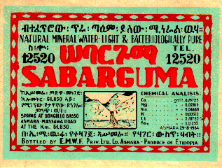
We drove down onto a flatter area, Sabarguma, another bowl like Ghinda, but greener and only a few hundred yards wide. We passed a cement-factory-looking building with a sign saying, "Sabarguma." This was the Sabarguma natural water plant, one of the biggest. We drank it's bubbly water all the time in Asmara. Tap water in Ethiopia was unsafe and Sabarguma's bubbling spring water made drinking from the bottle palatable. The label called it "natural mineral water--light and bacteriologically pure."
 |
 |
Leaving Sabarguma behind, we turned sharply left, entered a steep-walled canyon and dropped more than 700 feet (215 meters) into the opening to the Damas flats.
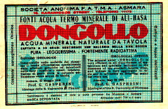
Just before we left the canyon, we passed a small sign pointing up a valley, "Dongollo." A rocky road led around a corner and up to the site of another water company. Dongollo water was one of Sabarguma's chief competitors in Asmara's stores and restaurants. We often mixed one of these bubbly spring waters with cheep wine to improve the taste of the first and extend the quantity of the second.
The Dongollo water label included the following "idrological opinion" in both Italian and English:
The mineral water 'DONGOLLO' is very efficient in all disturbances of metabolism and specially indicated in diseases of the stomach, bowels, liver, and kidneis[sic] is very agreeable to taste and is advisable as drinking water for every use.Asmara, May 22 1939
Prof. G. G A S P E R I N I
Idrologist of the R University of Florence
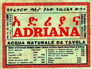
To complete the picture, the other big player in the mineral water game, Adriana, drew its water from Asmara wells and bottled it there.
 |
 |
The pleasant half of the trip was behind us. We were now below 1000 feet (305 meters) and had entered the heat of the "flats," the hellish hot zone. A hundred and twenty in the shade, which didn't exist, was not at all unusual. We were now in a desert of volcanic rock, shrubs, and rocky sand. It was time to move.
The road straightened and we accelerated to 65 miles per hour (104 kph), 25 (40 kph) above the national speed limit. No worry about anyone jumping in front of us here. Few walkers braved this inhospitable place and those we might have encountered had little cover to spring from. The shrubs were far back from the road.
Near the 59 k marker a sign pointed left to Ailet, a one-time hot springs resort. This road continued back up to the plateau where it joined the Asmara-Keren road at the 21 k marker bypassing Asmara entirely. The "Northern Cutoff" chapter tells you about this remote road.
A few miles down the road we passed through a gap between some mountains. Driving towards Asmara, we came on this gap from blind valleys. Suddenly we would see, framed by the walls of this gap, the wide, thorn-shrub, Damas River valley stretched out in front of a wall of high mountains. Ten years later and half the way around the world, I saw a similar plain and mountain wall during a bus ride up from Valparaiso to Santiago, Chili. There the mountains were the Andes. Here they were the western wall of the Africa's Great Rift Valley.
 |
From here, we just concentrated on getting to Massawa. Rocks and thorny shrubs were the only scenery and the 120°F (49°C) heat was oppressive. We passed through Dig Dig, Mai Atol, and Saati, small villages with few buildings.
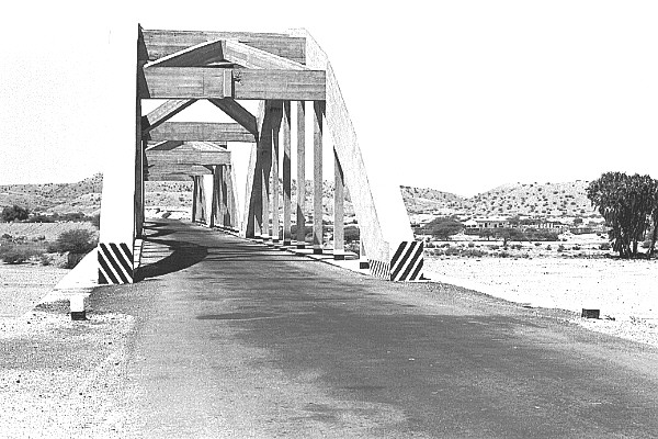
Just beyond Dogali, we crossed a large, cement bridge over a wide, almost forever dry river bed. Massawa was just beyond.
 |
Read the "Last Trip to Massawa" chapter for a full description of that beautiful port.
Thank you for your interest in this page. This is a full function preview page for this book. If you have come to this page from outside the www.WorksAndWords.com web site, perhaps you are not aware that this is one chapter in Ethiopia: Travels of a Youth, a CD-ROM book available here now for |