 |
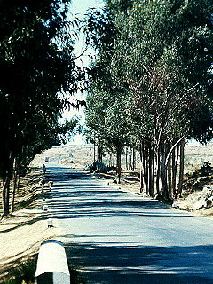
Bob and I sat in the Top Five Club having a fifteen-cent beer, listening to "The Ode to Billy Joe," and talking about a map I had found that morning.
While looking for information about the one-time Asmara to Massawa aerial tramway, I had found a map in an old magazine. The 31-year old, 1938 map included a road north of Asmara that connected the Keren road with the Massawa road, totally bypassing Asmara. Did the road still exist? If so, was it still in use? Was it passable?
I stopped Biene, a tall, ungainly, Ethiopian waiter whose observations on local matters usually were fairly accurate. "Do you know about a road connecting the Keren road to the Massawa road, Biene?"
"The only road from Keren to Massawa goes through Asmara."
"But isn't there a road starting around 20 kilometers north of Asmara that goes down to the Massawa road?"
"Oh, I know that one. Don't go there. Shifti are there." The ever-present shifti! Don't go here. Don't go there. Shiftis (bandits or freedom fighters) are everywhere! I suspected that probably meant that Biene really didn't know much about the road. Farther south in East Africa, when someone didn't know a distant people or hadn't been in the area, they had a similar response that went, "You don't want to go there. The people there are cannibals."
I took Biene's warning as a challenge.
A couple days later, I decided to check out the road. In those days, we had to request permission to travel anywhere besides directly down the roads between Asmara and Massawa or Asmara and Keren. But we could travel without permission in the "vicinity of Asmara," a location I never found specifically defined. Sure I'd never get permission to travel this road, I decided to use this vague "vicinity of Asmara" loophole. I knew full well that I'd be in for a lot of explaining if I were caught 37 miles (59 km) down the Massawa road without having signed out, or worse yet, if I were detained for any length of time by an Eritrean liberation group somewhere northeast of Asmara. I suppose, I could have tried, "Oh, I took a wrong turn up on the plateau and got lost." But I still would have ended up doing a couple weeks of extra duty.
With all that in mind and still determined to check out my discovery, I didn't sign out with the MPs for Massawa or Keren before I set off on my motorcycle toward Keren that day. But I couldn't totally dismiss Biene's shifti warning, so I left my camera, a constant companion, in the barracks.
I filled my gas tank before leaving the post. I figured the total distance I was about to cover should only be around 110 miles (176 km), give or take ten, if all went well. I carried enough gas for twice that. Even if I were to go down the mountain and have to return the same way, I figured 175 miles (280 km) at max.
|
Confident I had sufficient gas, I headed north toward Keren. Just before the 21 km (13 mi) marker, a gravel, secondary road went straight forward as the main road veered left. This had to be road on the map. It was near the right place and it looked big enough to be the one I was looking for. I didn't even have to slow down much as I moved from the smooth pavement to the rough, small gravel of the well maintained road. At 30 miles per hour (48 kph), my bike didn't notice the difference.
The rolling hills soon revealed a group of stone, corrugated-iron-covered houses scattered about on the left. The map called the village Af Delu. Several shamma-clad Ethiopians were walking here and there along the paths of the village. I exchanged waves with those near and continued on. In the back of my thoughts I wondered whether they were related to the bandits or some Eritrean liberation movement. "Will they let fellow members ahead know I am coming? ... Forget it! Keep going."
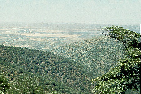
Moving across the plain, several times I was sure I was lost only to again find the border of white-washed rocks that marked the roadway. After miles of rolling, just-plowed farmland, I arrived at the edge of the plateau. I was, once again, on the brink of the Great Rift Valley. Oh, how every view into this natural wonder made me stop and look with awe! To the north, two long ridges thrust far out into what was otherwise a great valley dropping immediately in front of me. On the far ridge, I could trace a road ribboning its way out to a blur of geometric dots, a village. "Nakfa," I thought at first. "No, Nakfa is much farther to the north." It had to be just some uncharted village, important only to itself.
The closer ridge carried what was to be my road to the east. The horizon and its thin clouds faded into a distance haze. This view was different from the escarpment east of Asmara where several ridges and valleys separated the initial plateau viewpoint from the lowlands. Here the lowlands were the next step down. Down was, indeed, the only real direction here. This ridge was the only separation between me and the desert valley.
I was off to new horizons and a new lowland area 7,000 feet (2135 meters) below. Little changed in the first thousand feet (300 meters), other than the increasing slope of the land. As I continued back and forth down the ridge, the farms on the hillsides gradually looked greener than those above. And more people were moving about.
I had traveled more than 12 miles (19 km) from the main highway (my odometer was my only mile post) when the road split in two. Both branches were well maintained. This was not a fork I had expected here in the boondocks. Left or right? I really wasn't sure and I had no time for a wrong turn.
After taking the road to the right, I stopped a man walking toward me. "Does this road go to the Massawa road?" I asked in my best Tigrinya.
I interpreted his several-sentence answer to mean that it did. I continued east. The other fork went to the town on the next spur to the north, the one I had first thought was Nakfa.
The way became narrower and the mountains steeper. The foliage was heavy and rich. Great trees supported tons of hanging moss and vines. A lush green, wet smell hung heavily in the air. Lying along the north side of the ridge, this section of forest must have seldom felt the sun's heat. The humid, cool air was so different from the dryness only a few thousand feet back up the road. This unique forest lasted only a few hundred yards. Near the village of Filfil, I had stumbled onto the only tiny bit of rain forest left in Eritrea. But before I had a chance to fully appreciate and experience the delightful cool dampness, I was back in the dry sunshine.
As I descended, the mountain ridges flattened into hills, the road widened, and more and more farms took advantage of the area's fertility. But these were not small farms. They were large and well-organized. In fact, for the next several miles I passed through farm after farm that reminded me of the hilly farms in eastern Iowa. At times, I felt like I was actually home again. But my apprehensions interrupted me as I realized that I was a long way from Iowa, and now also a long way from Asmara and its safety. If those shifti were going to do something to me, now was the opportune time. I spent more energy than I wanted to spend watching for suspicious activity. But I only saw men plowing behind oxen and women working around the farm buildings. I dismissed the lingering fear again and drank in the surroundings.
After traveling more than 46 miles (75 km) from the Keren road, I began to suffer the hot, arid air of the Damas River flats overrunning the more temperate climate I had been passing through. I was down to 1,000 feet (305 meters) and in the desert. The remainder of the trip to the Massawa road became hotter and more oppressive with each revolution of the wheels.
Everything had changed. Here, everything was so dry. I wasn't sure where I was. My original plan had placed me in the Damas Valley a few miles north of the Massawa road. But nothing was familiar. The hills on the horizon all looked the same. I could have been more than ten miles (16 km) north of the Massawa road rather the few miles I had expected. Though I didn't panic, I wasn't totally calm either. I had a couple hours left before dark. But I needed at least an hour to drive up to Asmara, and now I had no idea how long it was going to take me to get to the main road. To add to my apprehension, I had not forgotten Biene's warning. I was now driving through scrub land, ideal cover for an ambush. Again I ignored the thought telling myself I could worry about it if it happened.
Wherever I was, I could only head south. The Massawa road had to be that way, no matter how far.
I bounced along a two-rut path between black volcanic outcroppings and acacia thorn bushes. Again and again I choked through powdery dust clouds as my wheels sang a loud "pluuuffff" as they lurched through puddle after puddle of red-brown powder. I crossed deep, dry creek bed after dry creek bed. Everything was shrouded in thorn bushes and dust and heat and the sweat leaking into my eyes. Only occasional groups of baboons and nagging thoughts of the shifti gave me something beyond the dust and holes to consider.
 |
I was dodging dust and baboons somewhere out there. |
This desolate area was the home of the one-time mineral hot springs resort of Ailet. But, though it was nearby, tens of paths crisscrossed the area and I never found the right one to Ailet.
Soon I climbed out of the dust up onto the Asmara-Massawa road at the Ailet sign, right where I had thought the road would end. I had traveled more than 56 miles (91 km) since leaving the Keren road. I quickly covered the 33 miles (59 km) back up the escarpment to Asmara. With the initial 13 miles (21 km) up the Keren road, the whole trip had been 102 miles (163 km).
With a little luck and a not so dangerous land, I had made it back safely. I had explored a new road and seen no shifti. I had half a tank of gas left. And the authorities never learned of my stretching of the meaning of "vicinity of Asmara." I only regret that I had not let myself be influenced into leaving my camera in my room that day. It never captured the vista of the escarpment, the mists of the rain forest, the Iowa farms in the hills, and the thorns and baboons of the desert. I cannot show them to you here, but they remain vivid in my mind.
Thank you for your interest in this page. This is a full function preview page for this book. If you have come to this page from outside the www.WorksAndWords.com web site, perhaps you are not aware that this is one chapter in Ethiopia: Travels of a Youth, a CD-ROM book available here for $13.95. |